From Bukhara I followed the Amu Darya on its northwesterly course. It cuts a fertile, verdant swathe through the otherwise inhospitable landscape of the Karakum desert to the south and Kizilkum to the north (the Black Sand desert and the Red Sand desert respectively, although, to be honest, both looked pretty sandy coloured to me) and is, and has been, the life-blood of the region for millennia where water is the most treasured commodity of all (an interesting, if useless, factoid, except for those who participate in pub quizes, is that Uzbekistan is one of only two countries in the world - the other being Liechtenstein - that is doubly landlocked i.e. a landlocked country that is itself wholly surrounded by landlocked countries (the Caspian and Aral seas don't count as they are technically lakes)). On its way the great river passes the historical cities of Khiva and Urgench before passing by Nukus, the capital of the autonomous republic of Karakalpakstan, and finally emptying into the Aral Sea. At least that's what older maps would have you believe. That's before the Soviet authorities, in their infinite wisdom, brought about the world's greatest environmental catastrophe, perhaps all the more catastrophic for the general worldwide ignorance and apathy that has accompanied it.
 |
| A couple of rusty boats sitting high and dry where the sea used to be at the "ship graveyard" at Moynaq. |
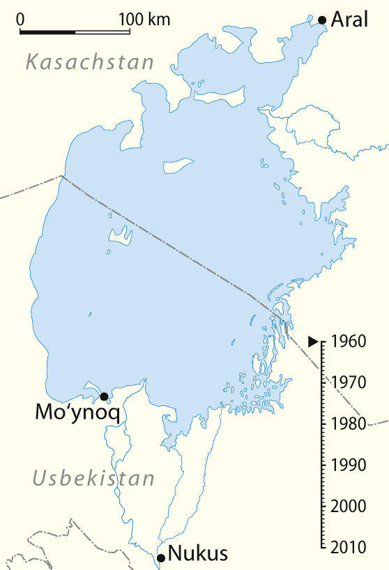
To break the Soviet Union's dependence on foreign cotton the leadership decided that Central Asia was the ideal place to cultivate the crop. The weather is indeed conducive to cotton plants, but the only problem is that it is a thirsty plant, and Central Asia is not doted with overly-abundant rainfall, although it does have the substantial Amu Darya and Syr Darya rivers. Initially things were OK and the USSR was able to supply its cotton needs and then some with the existing irrigation systems. Then in the 50's some bright spark noticed that there was still a lot of empty land in Turkmenistan and Uzbekistan that was being under-utilised and so a giant, 1300km canal was dug to divert the waters of the Amu Darya to the plains of Turkmenistan to water the desert for the glory of the proletariate. Whether someone had actually thought about the downstream consequences or that they were next to negligible I don't know, but the river's discharge into the Aral Sea dropped from 100 cubic kilometres (a lot) to less than half that, far below what was needed to maintain the sea's water level (the Syr Darya was similarly gouged for water). To satisfy cotton targets dreamt up in Moscow the Karakum canal was bleeding the Aral Sea dry. Due to poor construction (half the diverted water went to waste) and the inappropriate nature of the newly cultivated lands the increase in cotton production was pretty slight for the volume of water used. The effect on the sea was, on the other hand, far more noticeable. Over the past 50 years the sea has shrunk to almost 10% of its original size. The once thriving fishing industry of Moynaq and Aralsk (the two main ports on the sea, south and north respectively) that employed 40,000 people and provided food for the entire Soviet Union (up to a sixth of the country's entire fish catch) was decimated. The fisherman tried to desperately dig trenches to stay connected with the ever-receding sea which quickly disappeared from sight. Soon the salinity of the sea increased to such an extent that none of the fish species could survive. The canning industry limped on for several years more as the farcical Soviet system shipped in part of the catch from Vladivostok by train at great expense and waste. Soon the water level decreased to such an extent that the sea broke up into three separate sections. The Amu Darya no longer reaches the sea and can only feed a sorry-looking rump of a lake in the far southwest corner of the former sea. The river itself which is perhaps half a kilometre wide at Bukhara is less than 20m across by the time it reaches Nukus (where the thin sliver of water looks lost and forlorn in its formerly mighty riverbed), and that's still well over 120km from where the sea used to be.
 |
| A lone track snakes off into the horizon along the crusty-yet-soft ex-sea-bed. Without an experienced driver you are well and truly stuck in the mud (quite literally). |
The disastrous effects don't stop there though. The region around the sea used to have a mild, humid climate but with the tempering influence of such a vast body of water gone summers have become hotter and drier whilst winters are harsher and colder. This has led to a decrease in crop yields and an increase in fertiliser use, which in turn leaches into the water and makes its way to the sea, which as it recedes exposes the salt and sand of the sea bed along with these chemicals which are picked up and dispersed by the strong steppe winds creating an evil, unhealthy dust-laden atmosphere which has led to a dramatic increase in respiratory illnesses amongst the population. This infernal vortex of calamities just keeps piling up and getting worse. In Uzbekistan and Turkmenistan the political elite don't particularly care and it's business as usual with continued emphasis on cotton, a most inappropriate crop for the region, but which is called "Ak Altyn" (white gold) without the faintest trace of irony by the leaderships of both countries. Only in Kazakhstan, where the flow of the Syr Darya is still significant, have steps been taken to salvage something from the tragedy that is the Aral Sea. A dike has been built separating the northern section of the Aral, fed by the Syr Darya. This part has begun to stabilise and fish have been reintroduced, but it is the final nail in the coffin for the rest of the sea which has no inflow and is quickly withering away to nothingness. It is unlikely to survive this decade.
 |
| Animation showing the extent to which the Aral Sea has shrunk over the past 50 years. |
A trip to find what remains of the Aral is neither a fun, easy nor cheap excursion. Asphalt ends a few kilometres north of Moynaq after which you have some 200km of rough dirt tracks snaking through the dusty landscape until you reach the present-day shore. A fully equiped 4x4 car and a driver who knows the way are essential; and neither come cheap. When I got to Nukus I asked around to see if there were any groups going with whom I could spread the cost. I was in luck as the next day a French couple were heading off to the sea. In the meantime I had some time to kill in Nukus and so checked out what is undoubtedly one of the most unusual museums in the world. Not necessarily unusual in its subject matter, but more in its quality and location. Here, in a forgotten corner of the Soviet Union, Igor Savitsky, a maverick artist, built up the greatest collection of avant-garde and modern art in the country. Actually, the only collection, as such art didn't conform with Marxist-Leninist ideals and was not officially sanctioned. In fact creating such works often led to the artists ending up in hot water with the KGB. That Savitsky was able to create such a collection at all is down to the remote, and therefore harmless, location of Nukus and intense perseverance of Savitsky. Unlike fancy, modern art galleries in the West, where vast, bare, white walls house a handful of significant works by great names, the Savitsky is chock-full of works occupying every available inch of wall-space. The names are unknown as the artists were suppressed and denied exposure (the simple materials, such as cardboard and plywood demonstrate the limited means of many of the artists) but the pieces on display would merit their place in the Guggenheims and Tates of the world.
The next day I met up with my fellow travellers and our driver Shimbergen (Shimbek for short) with his sturdy UAZ Patriot, the cutting edge of Russian automotive technology (electric windows, reclining seats, digital odometer and even a sunroof). The closer you get to Moynaq the farmland slowly fades into grim, scrubby steppe. The wind also picks up and at times it was difficult to distinguish the land from the sky, or even see more than a few metres ahead due to the amount of sand in the air. Moynaq itself was one of the grimmest places I have ever seen. From a thriving port of 60,000 souls it has now shrunk to less than a tenth of that. Houses are empty and boarded up, the hulks of canning factories lie gutted and quiet, their machines sold for scrap years ago, and everything impregnated and tinged with the omnipresent sand. Below a bluff to one side of town, where the harbour used to be, among the sand dunes, lie a dozen rusting boats, all that remains of the once-busy Aral Sea fishing fleet, and one of the few sources of income for the town as tourists come to gawk at the ships stranded a hundred kilometres from their natural environment. The road continues for a few more kilometres before dipping onto the sea-bed. This is also initially paved, and a drilling rig poking up out of the horizon explains why. It's a lot easier to drill for gas on dry land than in water. Local Karakalpaks, who are not particularly fond either of the central government or Uzbeks in general, accuse the government of wanting the Aral Sea to disappear so as to get at the natural resources below the sea bed more easily, whilst at the same time destroying the local industry.
It took a further four hours to make the final 120km up onto the safe ground of the Ust-Yurt plateau and along to the last remnants of the sea. Once down to the new sea-shore there were a final , symbolic, several hundred metres to walk before finally reaching the water. Perversely these also proved rather uncomfortable due to the sneaky quicksand that lines the shore a mere metre from the sea and that gave me a nasty, though harmless, surprise before ritually dipping my hands in the water. The night was spent in flimsy tents, sorely lacking in guy ropes, with a constant wind blowing one of the sides right down into my face. Then in the morning we broke camp and headed back to Nukus, trying to protect our backsides as much as possible.
 |
| One of the reasons the Uzbek government is so apathetic to the plight of the Aral Sea: exploration and exploitation of the gas reserves under the ex-sea is now easier and cheaper. Plus money from oil and gas goes straight to the state coffers (via the state petroleum monopoly, Ubekneftegaz) and doesn't benefit or provide much employment for the native Karakalpak population. |
It took a further four hours to make the final 120km up onto the safe ground of the Ust-Yurt plateau and along to the last remnants of the sea. Once down to the new sea-shore there were a final , symbolic, several hundred metres to walk before finally reaching the water. Perversely these also proved rather uncomfortable due to the sneaky quicksand that lines the shore a mere metre from the sea and that gave me a nasty, though harmless, surprise before ritually dipping my hands in the water. The night was spent in flimsy tents, sorely lacking in guy ropes, with a constant wind blowing one of the sides right down into my face. Then in the morning we broke camp and headed back to Nukus, trying to protect our backsides as much as possible.
 |
| After 8 hours of driving we finally made it to the shores of the Aral Sea where I dipped my hands in - something that probably won't be possible in 10 years time. |
Truth be told I cannot say I enjoyed the trip: uncomfortable, expensive and at times boring (the steppe is not the most exciting of landscapes). Nevertheless I am glad I went. Not because of any potential bragging rights associated from visiting such a place, and one that soon won't exist; but because I found it important to see the destruction that we, as humans, can rain down upon the world through something as simple as ignorance and lack of foresight. It's therefore very frightening to see that we are unable to learn from past mistakes, with news this past week of the probability of a huge dam on the lower Mekong, which would likely have serious, and unforeseen, knock-on consequences. In many ways this disaster, though ignored by most of the world, is far worse than Chernobyl: certainly environmental, as a whole ecosystem has been wiped out, whereas with Chernobyl the wildlife in the surrounding areas is doing better now than it was before the explosion (although radiation affected many individual animals, the ecosystem as a whole has not suffered excessively).
 |
| Although the Aral Sea disaster has irrevocably changed the surrounding nature for the worse, there is still wildlife eking out a living in the harsh, steppe environment. The pesky ground squirrels never stayed still for long enough so I had to content myself with this, more pedestrian, fellow. |
No comments:
Post a Comment